Thursday, June 18, 2015

Water use in iceland

Water Use

I wasn't very surprised that there was all this water being stolen from streams, but I was shocked by the amount of water and the certain companies doing it. I didn't see Nestle being one of the main thefts of the water, Coca Cola I could see as well as Pepsi. To see all the damage and impacts from these companies on streams and lakes made me feel kind of sad, mainly because if it keeps up and nothing is done to slow it down then one day some places that people love to visit could be all out of water. I agree on whats being done to slow it and stop it, but I don't really agree with what is being done by the companies, yeah they need water to make their drinks, but if they aren't healthy drinks then why take the water and waste by turning it into something unhealthy.


Water Use in Iceland

On the global agenda, Iceland has been a strong voice in the fight against the pollution of the oceans. Icelandic waters are among the cleanest in the world. Iceland has taken an active role in international fora on the issue of peristant organic pollutants.
Although Iceland is famous for its unspoiled natural beauty, there are areas where care must be exercised. One of the most serious environmental problems in Iceland is the loss of vegetation by wind erosion. The Icelandic Soil Conservation Service has been fighting soil erosion since 1907 with considerable success. It currently aims at revegetating sites with a total area amounting to more than 2% of the country's land area. However, the fight to halt and reverse the erosion and desertification and to advance land reclamation, will remain one of Iceland's priorities in the environmental field in coming years and decades.


Sunday, May 10, 2015

Aquaculture

1. Aquaculture is the cultivation of aquatic animals and plants, especially fish, shellfish, and seaweed, in natural or controlled marine or freshwater environments; underwater agriculture.


3 Pros of Aquaculture
Here are the following benefits that made fish farming a good thing for people.
1. It is a Good Source of Living
It provides a very secure and stable way for fisherman to earn a living. It also grants them more time at home, and a longer time frame of which they can harvest fish.
2. Fish Farms can be Made on Coastal Areas and Inland Lakes and Rivers
One of the good things about this is that fish farms can be made anywhere. The farms can be in the form of artificial ponds, enclosures within a natural setting and large tanks.
3. Keeps a Growing Supply of Seafood
Seafood provides many key nutrients and vitamins to the human body. Fish farming brings a more steady supply of seafood into areas that may not normally have this type of access. It also helps to lower the price of seafood.

3 Cons of Aquaculture

These are the following reasons that affect the industry and make fish farming also a drawback in the economy.
1. It Contributes to the Growing Issue of Water Contamination
As mentioned, fish farms can be made anywhere, where water is easy to be supplied. However, it is also for this reason that it made contaminating the natural water source easier. Often, waste products such as eaten foods, feces as well as dead fish are flushed into the water supply. Which raises large concerns about water contamination.
2. There is a Risk of Eating the Supplied Fish from Fish Farms
Even fish farms are using pesticides to avoid pest infestations. The fish are also mass treated with drugs in order to prevent sickness and disease. These are chemicals that not only affect the ecosystem, but also consumers health.
3. It Comes With an Environmental Impact
Large portions of the aquatic ecosystem have been destroyed in order to sustain fish farms.
Protect The Future Of Fish
3. I think aquculture or fish farming is bad thing because Fish farms, or “aquafarms,” discharge waste, pesticides, and other chemicals directly into ecologically fragile coastal waters, destroying local ecosystems. And aquaculture farms that raise fish directly in fenced-in areas of natural waters kill off thriving natural habitats by overloading them far beyond their capacity. Waste from the excessive number of fish can cause huge blankets of green slime on the water’s surface, depleting oxygen and killing much of the life in the water.

Monday, April 20, 2015

Plate Tectonics

The tectonic plates whose turbulent interactions formed Iceland, are the Eurasian tectonic plate and the North American tectonic plate. Spanning the Mid-Atlantic Ridge, Iceland emerged as a result of the divergent, spreading, boundary between these two plates and the activity of Iceland´s own hotspot or mantle plume. As the plates moved apart, excessive eruptions of lava constructed volcanoes and filled rift valleys. Subsequent movement rifted these later lava fields, causing long, linear valleys bounded by parallel faults. The divergence of the ridge started in the north about 150 million years ago and 90 million years ago in the south. These movements continue today, accompanied by earthquakes, reactivation of old volcanoes, and creation of new ones. Iceland is the largest island on the ridge because of the additional volcanism caused by the hot spot beneath the country, which moves slowly towards the northwest.

The tectonic plates move towards east and west, and both the North American and Eurasian systems move to the northwest across the hot spot. On top of hot spots there's generally a 20-100% molten layer at the depth of 5-20 km, which supplies sufficient material for eruptions. Eruptions occur about every 5-10 years and primarily consist of basaltic lava and tephra. A few long-lived centres, such as the volcano Hekla, erupt more silicic magmas.  

Faults and Folds in Iceland

Vertical faults having both opening and vertical displacements are common in southwest Iceland, and hypotheses vary regarding whether they propagated to the surface from below or from the surface downward. We address this issue through a study of vertical faults and associated surface fracture zones in regions of both oblique and normal spreading in southwest Iceland. Individual fracture segments are commonly rotated out of the general trend of the fracture zone, suggesting oblique motion along subsurface normal faults. These faults commonly breach the upper hinge lines of narrow monoclinal folds that flank many fault traces on the hanging wall side. Based on these field observations and the results of numerical models, we propose that 60-75 o dipping normal faults in the subsurface propagated to the surface from below. Vertical fractures formed at the upper tips of the faults at depths of between 250 and 500 m (25-50% of the fault length) in response to stress concentrations along the tip line. Model results indicate that narrow monoclinal folds develop at the surface above these vertical fractures, which subsequently breach the monoclines along the upper hinge line, forming vertical fault scarps and open fissures at the surface. If vertical fractures utilize pre-existing cooling joints in basalt to connect directly to the surface, the hanging wall is able to pull apart from the footwall without the development of a surface monocline along the fault trace.


Earthquake in Iceland

The 2008 Iceland earthquake was a doublet earthquake that struck on May 29, 2008 at 15:46 UTC in southwestern Iceland. The recorded magnitudes of the two main quakes were 5.9 Mw and 5.8 Mw, respectively, giving a composite magnitude of 6.2Mw.There were no human fatalities, but 30 injuries were reported and a number of sheep were killed. The epicenter of the earthquake was between the towns of Hveragerði and Selfoss, about 45 kilometers (28 mi) east-southeast of the capital, Reykjavík. In Iceland the ridge is somewhat off-set, creating two transform faults where plates move horizontally along each other. One is in the north of the country and one in the south; the strongest Icelandic earthquakes happen along those transform faults.Many farms were also affected.In the town of Selfoss, near the epicentre, buildings were damaged and up to 20 people needed treatment for minor injuries.Residents in the capital felt buildings shake when the tremors struck and the road between Reykjavik and Selfoss was closed by quake damage. 

Impacts of fishing

 Fishermen: Once all the fish are gone from the oceans they wont be able to make living off of fishing.

 Consumers: Seafood restaurants will go out of business and people who live off eating fish will have a tough time finding ways to live without it.

 Governments: People will get angry at the government and blame them for not doing anything to help save the fish and therefore could change the results of future elections.

Environment: The way of life in oceans could change for the worst if fish species start going extinct if not endangered already.

Part 2

Iceland has created one of the most modern and competitive seafood industries in the world, based on sustainable harvest and protection of the marine ecosystem. The fisheries management in Iceland is primarily based on extensive research on the fish stocks and the marine ecosystem and biodiversity, and decisions on allowable catches are made by the Ministry for Fisheries on the basis of scientific advice from the Icelandic Marine Research Institute. Catches are effectively monitored and enforced by the Directorate of Fisheries. In 2007, all stakeholders in the fisheries sector, signed a statement on responsible fisheries, intended for everyone concerned about the status of the fish stocks and responsible fisheries, particularly the numerous parties that purchase and consume Icelandic fish products. These are the keystones of the Icelandic fisheries management intended to ensure respoIceland maintains a 200 nautical miles exclusive fishing zone (758,000 km2 ) that includes some of the richest fishing grounds in the world.nsible fisheries and the sustainability of the ocean’s natural resources. There are 1,696 fishing ships in Iceland (2013), of which 783 are machine ships and 51 trawlers.

Sunday, April 19, 2015

Mining

                            Shaft Mining 


Shaft mining or shaft sinking refers to the method of excavating a vertical or near-vertical tunnel from the top down, where there is initially no access to the bottom.

Pros:- produces very little waste and mill tailings
                  easier permiting and grade control
                  less damaging to environment

Cons:- high cost per ton of ore
                  ventilation
                  more hazardous to workers

                            Strip Mining 


Strip mining, or open-pit mining is a surface mining technique of extracting rock or minerals from the earth by their removal from an open pit or borrow. This form of mining differs from extractive methods that require tunneling into the earth, such as long wall mining.

Pros:- Easier access to materials
                  Easier to transport materials to the destination
                  Less hazards in regards to mining in tunnels or underground

Cons:- Alot more disel fuel burned to transport goods
                  Blasting is also required making it highly dangerous to anyone                           around and the atmosphere
                  AMD, or acid mine drainage, is a serious environmental concern                         associated with strip mining.

                                                              Part B 
» Spouse of a miner would prefer strip mining a lot more because it is a lot          safer and she wants her husband to be safe at work.

» Owner of a mining company would prefer shaft mining because he would            want his employees to be safe and it costs a lot less to create.

» Environmentalist would prefer shaft mining because it doesn't do as much         damage to the environment.

» Owner of nearby ski resorts would prefer shaft mining because you                    wouldn't be looking at a gaping hole coming down the mountain and there's      less chance of deadly chemicals coming out into the atmosphere.

» Politician would prefer strip mining because it is a lot cheaper and get more        profit.


                                              Part C 
 
Diatomite was a leading export commodity in 2002, and ferrosilicon production and geothermal power were Iceland's major mineral industries. Diatomite production, from Lake Myvatn, was 28,000 tons in 2001, and the Ministry of Environment issued a permit for dredging in a new area of the lake, as government studies determined that additional mining would not damage the environmentally sensitive lake. Iceland also produced hydraulic cement, nitrogen, pumice, salt, scoria, sand (basaltic, calcareous, and shell), sand and gravel, and crushed stone (basaltic and rhyolite); these minerals were used by local industries. Among Iceland's other mineral resources, spar and sulfur deposits, once mined, were no longer worked extensively; peat was common, but little used; and sulfur and lignite were being processed experimentally, the former with the use of subterranean steam. The country's aluminum plant and ferrosilicon plant relied on imported raw materials and inexpensive hydroelectric and geothermal energy.


Tundra Biome

Where is Tundra located ?

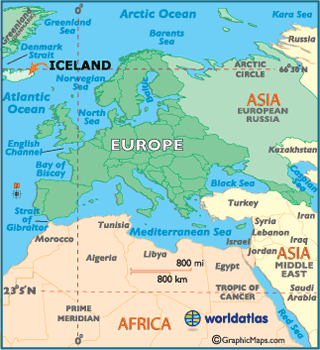
The tundra is located at the top of the world, near the North Pole. This enormous biome, extremely uniform in appearance, covers a fifth of the earth's surface. Tundra is the coldest of all the biomes. Tundra comes from the Finnish word tunturi, meaning treeless plain. It is noted for its frost-molded landscapes, extremely low temperatures, little precipitation, poor nutrients, and short growing seasons. Dead organic material functions as a nutrient pool. The two major nutrients are nitrogen and phosphorus. Nitrogen is created by biological fixation, and phosphorus is created by precipitation.


Climate in Tundra :-

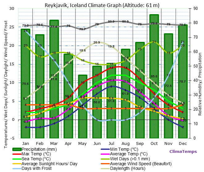
The average winter temperature is -34° C (-30° F), but the average summer temperature is 3-12° C (37-54° F) which enables this biome to sustain life. Rainfall may vary in different regions of the arctic. Yearly precipitation, including melting snow, is 15 to 25 cm (6 to 10 inches).

Animals found in Tundra :-

Polar Bear

Polar Bears appear to have a white coat; however, the 
actual hairs are translucent and clear. The skin of the Polar Bear is 
black. The coat and skin are adapted to absorb sunlight and retain 
heat. Like many animals of the tundra, Polar Bears have short ears to 
minimize heat loss. Polar Bears' diets consist mainly of seals. Polar Bears will use a variety of tactics while hunting seals, and these tactics will usually 
involve stealth and patience.Polar Bears will occasionally feed on 
other animals including walruses.Polar Bears will also sometimes 
feed on the carcases of dead whales.  


Caribou

Caribou are migratory animals and are known for mass migrations 
across the tundra in search of food. Caribou are well adapted to living 
in the tundra with thick fur and skin that enable them to enter frigid 
rivers while migrating. The hooves of caribou are wide to assist 
supporting it on surfaces such as mud and snow, and wide hooves will 
also help the caribou to dig and swim. The diet of the Caribou varies as the seasons change.  In the summertime, when vegetation is more plentiful, Caribou will feed on a  variety of plants including willow leaves.  In the wintertime, Caribou will use their hooves to dig through snow to get to moss and other lichens that lie beneath the arctic surface.


Arctic Fox

Like many foxes, the Arctic Fox builds a den. For the Arctic Fox the 
den can sometimes be in a hillside or river bank, and will usually have 
multiple entrances and exits. The Arctic Fox can be found in arctic or 
alpine tundra. Like many animals of the tundra, Arctic Foxes have special adaptations to help them survive in extremely cold climates. These adaptations include fur on its paws to help keep them warm, a thick, dense coat of fur around its body, short ears,  a small body, and a large and bushy tail that it uses to curl around its body. Arctic Foxes' diets consist of small mammals including voles and lemmings, as well as on birds and their eggs.  Arctic Foxes are opportunistic and will sometimes scavenge on dead carcasses of 
animals, and they are often seen following Polar Bears to feed on the 
leftovers the bears leave behind.  Arctic Foxes will also eat some 
vegetation such as berries.


Arctic Hare

Arctic Hares can be found in various tundra areas of Greenland and northern Canada.They will sometimes forage shelters in the snow to help them survive the extremely cold temperatures of the tundra. Arctic Hares have large hind feet that enable them to move very quickly across the snow. They also have claws that help them to dig through the snow when looking for mosses or other vegetation to eat.The Arctic Hare's diet consists of buds, berries, twigs, mosses, woody plants and other types of vegetation that can be found in the tundra.   


Musk Ox

Musk Oxen have an outer coat made of long, brown hairs and an inner coat called qiviut which consists of wool.This is a special adaptation that helps the musk ox survive the freezing temperatures of the tundra. Musk Oxen are vegetarian and will eat much of the vegetation that is available in the tundra. This includes willow shoots, lichens, grasses and shrubs.  


Snowy Owl

Snowy Owls will most often feed on small rodents including lemmings 
and voles. Rabbits are another staple of the Snowy Owl's diet.The 
owls are opportunistic and will also feed on other types of birds such 
as ptarmigans as well as bird eggs of larger birds. Snowy Owls will build their nests on the ground, typically in a higher place than the surrounding land so that they will have good visibility to predators and prey. Snowy Owls have a 
thick layer of feathers on their body as well as their feet to enable them
to survive in the tundra. 


Plants In Tundra :- 

Arctic Moss

The Calliergon giganteum is an aquatic plant found growing on the bottom of tundra lake beds and in and around bogs and fens. It is a member of the Siberian tundra biome. Like all mosses, Calliergon giganteum is a bryophyte. They have rhizoids (tiny rootlets) instead of roots. They never have wood stems. They have tiny leaves, usually only one cell thick. There are lots of leaves on the stem. They do not have flowers.
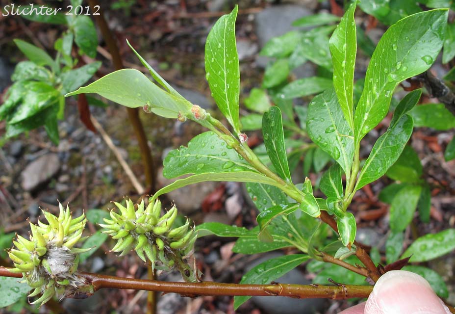

Arctic Willow

Arctic Willow is 15-20 cm in height. It has many different shapes, but sometimes has long trailing branches that root where they touch the surface. Rock willows/Arctic willows grow prostrate, shrub, and carpet. The leaves are oval shaped with pointed tips, wedge shaped bottoms, and have little stalks.The leaves are dark green on the bottom and a lighter green on the top.They have net like veins and long hairs that cover their leaves. The flowers of the Salix arctica are upright scaly spikes that are unisexual flowers with no petals.


Bearberry

Bearberry is a very useful plant. All parts of it can be used in some way. The fruit can be eaten and cooked with other foods. The roots can be made into a tea that can treat a constant cough or slow down menstrual bleeding. A tea from the stem is used to prevent miscarriage and to speed up a women's recovery after childbirth. The leaves can be added to tobacco or used as a substitute for it. A tea made from the leaves can be drunk to treat kidney or bladder problems. It's fine silky hairs also help to keep it warm.Leathery leaves are also an adaptation to the cold of the tundra


Caribou Moss

It grows on the ground and on rocks. It looks like a foamy, gray-green spongy mass, and grows to be 1 to 4 inches high. The stems, or stocks, are hollow, and branch out many times. 


Diamond Leaf Willow

The twigs on a willow are soft, slender, and they bend easily. A willow has thin branches. The leaves are narrow and grow alternately on the branch. Some leaves have serrated edges.Willows have clusters of flowers that look like white, fuzzy caterpillars and are about 1 inch in length.When the willow blooms on the tundra it looks like a bumpy, fuzzy carpet covering the ground.The diamond leaf willow provides much needed food for grazing animal of the tundra, like musk oxen, and caribou or reindeer. 
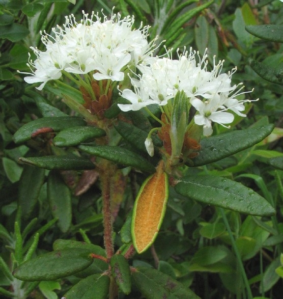


Labrador Tea

It has woolly branches with narrow 1 to 2 inch leaves which are smooth on the upper side, with rusty hairs underneath.They droop slightly and edges are rolled under, and are a leathery green in color. At the ends of the branches are tiny clusters of white flowers.The tea is very rich in vitamin C.Bees are attracted to the flowers, but animals don't eat them because they are said to be slightly poisonous. 
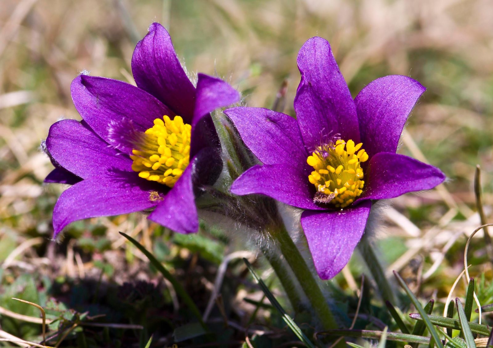


Pasque Flower

The Pasque flower has several stems that rise 6-8 inches off the ground. On each stem is one flower with 5-8 petals. The range of color in the petals is from dark lavender to almost white. In the center of the flower are yellow stamens. Below the flower, around the stem is a leaf covered in silky hairs, as is the rest of the plant. The fruit of the plant is a plum that is achenial, which means that one seed is attached to the ovary wall, like a strawberry seed.
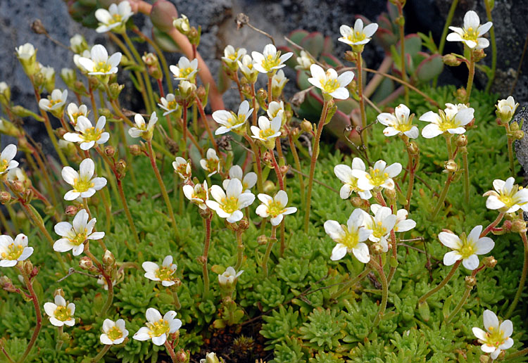


Tufted Saxifrage

Tufted Saxifrage is a small perennial that grow in thick mats on the tundra. It has several straight flower stems which can get 3-15 cm high. The leaves are rigid and very hairy and only 5-10 mm long. Their tips divide into 3 lobes.The Saxifrage has a well-developed underground root system forstoring carbohydrates, so that they can respond quickly to the cold weather of the tundra. Saxifraga heuchera is one of the few saxifrages used as an ornamental plant.


Soil :-

Tundra has unique soil structure, permafrost, forms and dominates the biology. Permafrost is a layer of soil that remains frozen year-round.The soil above it may thaw during the summer, but the soil below remains frozen and thus biologically inactive. Further, the permafrost forms a barrier; in temperate climes many animals overwinter by burrowing down into the soil to a point below where the soil freezes.This is not possible in the tundra soils, and thus animals must contend with freezing over the winter. Permafrost limits root penetration to deep soil layers, effectively insulating lower soil layers from biological activity. Materials in permafrost layers are trapped and remain stored, mostly inert, for eons. Water becomes limiting, because soils don't have much depth in which to store water, and there is only a short period during the growing season when it thaws and becomes available. Thus, water shortages can be a problem in some tundra areas. In other areas, tundra is low elevation, and water collects and makes the ground boggy during the summer months.


Limited Factors :- 

Temperature

The temperature in a tundra biome ranges between −94°F in winter to 54°F in summer. In contrast, mammals can survive in this harsh climate, owing to their ability to regulate their body temperature.

Sunlight

As a tundra biome is located at the poles, it is in darkness for a considerable part of the year. Lack of sunlight for a part of the year also means that plants grow in a tundra biome only during summer.

Poor Soil

Tundra plants also bear the brunt of poor soil. The soil in this biome is not just nutrient deficient, but also very shallow. As a result, trees cannot delve their root deep into it. 

Limited Growing Season

As the region is subjected to darkness for nearly half the year, the process of photosynthesis is hindered, which, in turn, limits the growth of plants. The end result in a short growing season.This seasonal availability of food reflects on the abundance of animals in this ecosystem.

Food Supply

The shortage of food supply resulting from lack of sunlight for a part of the year, short growing season, and poor soil limits the population of herbivores and omnivores by forcing them to migrate in search of food and affecting their rate of reproduction.

Competition

hen the number of caribous in the Arctic tundra comes down, carnivorous species like gray wolves and wolverines start competing. Eventually, the food shortage resulting from this competition either results in their death, affects their rate of reproduction, or prompts them to migrate, thus restoring the balance in a tundra ecosystem.

Predation

When the caribou population increases, gray wolves have abundance of food at their disposal. This, in turn, boosts their reproduction rate and results in an increase in their population. In this manner, the population of both species is balanced out.

Human Impact :- 

Human impact on the tundra has generally not been a positive one. Because the tundra is such a delicate environment, even the slightest change in conditions can threaten the entire biome. Recent human activities have largely undermined the habitat of the indigenous wildlife through hunting, global warming, oil drilling, overdevelopment, and pollution.


BIBLIOGRAPHY

http://www.appstate.edu/~neufeldhs/ecosystems/biomestundra.htm
http://www.tundraanimals.net/tundraanimals/rockptarmigan.html
http://www.blueplanetbiomes.org/tundra_plant_page.htm
http://www.mbgnet.net/sets/tundra/where.htm
http://www.ucmp.berkeley.edu/exhibits/biomes/tundra.php
http://www.buzzle.com/articles/limiting-factors-in-a-tundra-biome.html
http://www.ehow.com/facts_5903440_human-impact-tundra_.html


Saturday, April 18, 2015

Waste Managment

Being based mainly on data from SORPA (www.sorpa.is), the biggest waste treatment
facility in Iceland, servicing the capital area of Reykjavik and covering ca. 62% of the
Icelandic population. In 2004 the amounts of waste generated in 2002 were assessed
in a more detailed way, e.g. by using more concise definitions of waste streams and
inclusion of more waste-types, such as agricultural waste, industrial waste and
construction & demolition waste. It became clear that waste amounts were in fact
significantly higher than previously estimated and therefore needed to be revised
accordingly. Iceland covers an area of 103.125 km2 and has a population of 299.404 (December 2005). With an average population density of 2.8 inhabitants per km2 , almost two out of three Icelanders (62 per cent) live in the greater Reykjavik area. Abundant land space, a clean environment, renewable energy sources as geothermal heat and hydroelectricity, harsh weather conditions during a large part of the year and relative long distances between municipalities and to the European market are a few of the most eye-catching characteristics about Iceland.

Climate and Climate Controls of Iceland

Iceland enjoys a much milder climate than its name and location adjacent to the Arctic circle would imply. A branch of the Gulf Stream flows along the southern and the western coast greatly moderating the climate. However, this brings mild Atlantic air in contact with colder Arctic air resulting in a climate that is marked by frequent changes in weather and storminess. Furthermore this leads to more rainfall in the southern and western part than in the northern part of the island.

Hurrican Ike

Hurricane Ike's remnants combined with an unusual depression that affected southwestern Iceland on September 17, three days after Ike became extratropical. The storm produced 9 m (30 ft) waves along southwest coasts of the island. Rainfall peaked near 200 mm (7.9 in) close to Reykjavík. Wind gusts were measured up to 89 miles per hour (143 km/h). Strong winds on the backside of the system produced a large dust storm in northern areas of the island.Some areas of the country experienced 47 m/s winds (>100MPH), the strongest gust of wind measured 52.9 m/s and in my area the strongest gust measured 41.9 m/s.

Wednesday, April 15, 2015

Air Masses, Global winds, and Types of Rain in Iceland

1. Iceland has considerably milder climate than its location just south of the Arctic Circle would imply.
2. The dominant wind directions in Iceland are from easterly directions, E, NE-SE.
3. Not able to find.

Introduction to Weather and Climate

1. The sun radiates eat the warms the earth.
2. They receive more direct sunlight throughout a calendar year which keeps it warmer than polar regions.
3. Albedo is the fraction of radiation that reflects back into space. The black roof would absorb more radiation since it has a lower level of albedo.
4. Lapse rate is the rate of atmospheric temperature decrease when altitude increases.
5. Aspect is the compass direction facing a slope. The direction a slope faces can affect biotic and physical features. Plants would grow better on the south side facing side of a mountain in the northern hemisphere.
6. Since the Earth is tilted on its axis going around the sun, certain hemispheres get more sun at one time of the year than others.
7. Land heats up faster because the heat gets absorbed in the surface unlike water which has different physical properties and has to heat all the way through which takes longer.
8. The climate is a lot drier and certain plants can't grow their because of the lack of water, but helps plants like wheat grow really well since they don't need a lot of water.
9. It keeps Norway's coastal water from freezing over with its strong winds even though Norway is close to the arctic.
10. The Alaska current runs past BC.
11. Adding carbon dioxide impacts the atmosphere by heating up the temperature which helps advance global warming.
12. Convection is the collective, concerted movement of a group of molecules within fluids and rheids, usually through diffusion or advection or even a combination of both.
13. Wind is the natural movement of the air, mostly in the form of a current of air blowing in one direction.
14. An urban heat island is an area that is significantly warmer than its surrounding rural areas and it is caused by human activities and can mainly be noticed when the winds are weak in the area. It is mainly caused when the modification of land surfaces use materials that impact the storing of sort-wave radiation. 

Iceland and 5 Themes

PART A


Location »

Absolute location of  Golden Temple is 31.6200° N, 74.8769° E
The relative location of Golden Temple is  Amritsar, Punjab, India


Human Environment Interaction »

We depend on environment. People depend on rivers for transportation and water.
We adapt to environment by wearing clothes suitable for different weathers.


Movement »

Airplanes are one of the example of the movement. It moves from place to place every day, transporting food and humans.

PART B » ICELAND 

Location:- Absolute location is 65.0000° N, 18.0000° W
                 Relative location is just below the Arctic Circle, Iceland is bordered by the North Atlantic                    Ocean, Greenland Sea and the Denmark Strait.

locator map of Iceland

Human Environment Interaction » 

Depend :- There are rivers in Iceland. They are used for fresh water and transportation. Iceland is surrounded by water which cause natural disasters, food from fish, and transportation/import/ export

Adapt :- They are starting to use hydrogen-fueled cars. Hydrogen-fueled cars causes less greenhouse gas emissions.Therefore the environment improves. Since Icelandic cuisine is made mainly off of fish and other seafood, so the sea creatures may die and go extinct in a shorter amount of time.

Place »

Human :- The people of Iceland share a love of art, such as drawing, and a love of literature.  The primary language spoken by the people is called Icelandic.

Physical :- In Iceland there are glaciers, rivers, and hills throughout the country. Interestingly, the entire country is surrounded by water. 

Movement »


Of goods :-  The people of Iceland use boats, trucks, and planes to transport goods throughout their country and also to export goods to the rest of the world. Fishing is widely popular so it's not surprising that seafood is one of the primary  exports.  Iceland makes a large portion of its money by exporting goods to many countries, including the United States.

Of ideas: Telephones are very important to the people in Iceland - it is the main way people communicate. The Icelandic people also enjoy many radio stations (there are approximately 70 different stations throughout the country) and they use the internet as well. All of these things help ideas travel throughout Iceland.

Of people: Because there are no public train stations in Iceland,  people travel by cars. The country also has 86 airways. The price to fuel  cars, trucks, and planes is very high, which impacts their economy.


Region »

Iceland is part of the Nordic region. The Nordic region consists of 5 countries and 3 territories. The countries and territories have some similar parts in their history such as political system. The Nordic countries cooperate together in the Nordic Council.

Thursday, February 19, 2015

Iceland and 4 Spheres

In Iceland, they have a lot of volcano's so most of the disasters are from volcanic eruptions. 

Volcanoes => Lithosphere/ Atmosphere/ Hydrosphere/ Biosphere 

Volcanoes (an event in the geosphere) release a large amount of particulate matter into the atmosphere.  These particles serve as nuclei for the formation of water droplets (hydrosphere).  Rainfall (hydrosphere) often increases following an eruption, stimulating plant growth (biosphere). Particulate matter in the air (atmosphere) falls out, initially smothering plants (biosphere), but ultimately enriching the soil (geosphere) and thereby stimulating plant growth (biosphere).

Friday, February 13, 2015

Iceland

Map:- Latitude is 64.8343'N 
          Longitude is 18 .9770'W

Capital city:- Reykjavik 

Type of Government:- Constitution Govt.

Population:- 325,000 ( 2014 ) 

Where is it :- Nordic Island in Europe; between north atlantic and artic ocean 

How big is it ( km ) :- 103,000 km